Center of the Contiguous 48 States
Lebanon, Kansas
Use your favorite adhesive and mount a Rand McNally map of the contiguous 48 United States on the wall (if it has all 50, we’ll just ignore Alaska and Hawaii for now). I’ll wait. Done? Good. Now take a dart and take your best shot to hit the center of the map. If you’re a decent darts player, you should land in the vicinity of Lebanon, Kansas, and with close to the same accuracy as L. T. Hagadorn and L. A. Beardslee achieved in 1898. As part of the U. S Coast and Geodetic Survey that year, engineers Hagadorn and Beardsly cut a detailed cardboard form of the U. S. at the time (Hawaii, Alaska, Arizona and New Mexico were not yet states, but the latter two did not affect the shape). This was rested on a point until it balanced, placing the location in the middle of Johnny Grieb’s hog farm in Lebanon, Kansas (about a half mile from the current location of the marker). Since Farmer Grieb didn’t want a bunch of city folk traipsing through his fields, the current site was selected. A slightly more scientific method of centering the intersection of even-length lines between the northernmost and southernmost and the easternmost and westernmost points of the contiguous U.S. would place the center some 215 miles away as the crow flies near the appropriately named Center, Kansas in Chautauqua county, but since no one really agrees on the most accurate means of calculating the point, Lebanon is as good a location as any.
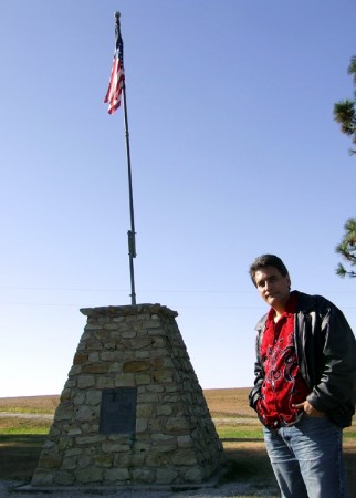
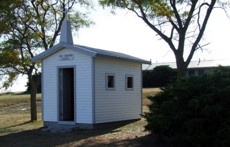
The State of Kansas pitched in to build a road (Kansas 191) out to the spot from what is now US Highway 281 to the T-bone intersection of AA Road. In 1940, the Lebanon Hub Club sponsored a stone monument erected at the site; shortly thereafter came a motel on the crest above the small park, and a tiny chapel. After the site failed to become an international tourist attraction as thought, the motel closed. In June of 2008, the chapel was destroyed by a driver barreling down Highway 191 and failing to make the turn at the T-bone (fortunately for all us thrill-seekers and historians, it has since been rebuilt). The chapel features a tiny lectern and pews that hold 6 guests for anyone wishing to renew their vows. The miniscule church appears to be open 24-7; the area doesn’t appear to be threatened by the criminal element out to steal the US-shaped flag and cross on the wall, the guest book or the furniture. While I was there, a single car passed, neither stopping nor slowing down for a look (obviously a local). In fact, the only sign of life besides me was a chicken that would occasionally dart out of the bushes beside the chapel; if I died there, my body probably wouldn’t be discovered for days.
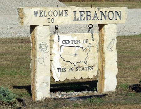
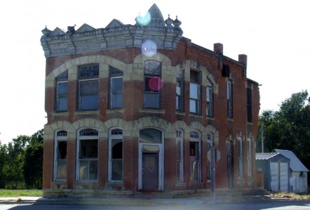
As you drive north into the heart of the teeming metropolis that is Lebanon (with a population of 364 as of the last survey) you see stone, wood and metallic highway signs informing you that you have reached “Lebanon, Kansas, Center of the 48 States”. A sign telling you where to turn left onto Highway 191 would probably be helpful, although once on the road you won’t miss the spot since if you drive straight through the end they’ll be forced to build another chapel. A sign across the road states that “Lebanon Has Souvenirs”, but I drove up and down Elm Street (US 281) several times and neglected to find as much as postcard. I decided to see what life was like in the center of town. Main Street (yes, it’s actually called Main Street) was largely deserted; a considerable amount of the former storefronts appeared to be abandoned, with some of the buildings missing doors and windows (apparently for years). The only activity appeared to be an event sponsored by the Lebanon United Methodist Church where horse-drawn carts were giving hayrides; I would have stayed for the shindig, but I had another four hours to go to get back to Omaha, Nebraska.
Sadly, this little chunk of heartland Americana is slowly evaporating, suffering the effects of “rural flight” (the townsfolk are leaving in droves for the big city). In our urban cities and towns, the abandoned buildings would be covered in graffiti, strewn with garbage and become hangouts for the criminal element, but in this shrinking town they simply become ghostly shells of their former glory. I imagine the local business that are left appreciate the patronage of people like me that are attracted to the center of the Old 48 like iron to a magnet, so if you happen to be in Kansas passing through (maybe to see the world’s largest ball of twine in Cawker City), make the side trip to see where the dart landed. Maybe you could call a friend and let them know that our country really is centered on you.
“Official” Geographic Center of the 48 Contiguous States
Junction of AA Road and Kansas 191
Lebanon, Kansas 66952
Marker GPS Coordinates: 39°49’41.81″N 98°34’45.96″W
Location GPS Coordinates: 39°50′ N 98°35′ W
Geographic center of center of the 48 States using the intersection of extremes:
GPS Coordinates: 37°15’2″ N 96°21’30” W


I bet a lot of Americans are afraid to visit because of the whole terrorist element found in Lebanon. 😉 You know like the war and Russian invasion of Georgia a few months back? Scary place our country has become!
There’s no big worry about terrorism in THIS Lebanon, Joshua… not much to blow up. Of course, the reckless driver who took out the original chapel was probably considered a terrorist…